NASA’s INCUS storm satellites are trying to catch the minutes forecasts miss
Two of three INCUS SmallSats have finished assembly and testing. The useful story is not a launch countdown, but a new way to watch tropical storms change in 30 and 90 second steps.

A space mission can sound remote until it is really a timing problem. NASA’s INCUS mission is not being built to produce dramatic storm pictures for the evening bulletin. It is being built to measure what changes inside tropical storms over very short intervals, the kind of minutes that models and forecasters often have to infer rather than see.
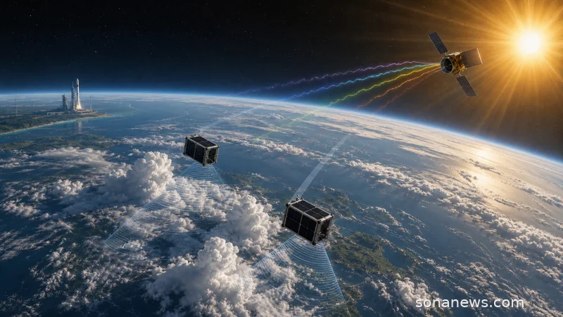
NASA’s Jet Propulsion Laboratory said on 5 June that two of the three small satellites for INCUS, short for Investigation of Convective Updrafts, have completed assembly and testing. Testing on the third SmallSat is scheduled for completion no earlier than September, ahead of a planned 2027 launch. The satellites are being prepared for shipment to NASA’s Wallops Flight Facility in Virginia, where the mission is due to start its climb to low Earth orbit.
The update is a progress note, but the science behind it is larger than a launch calendar. INCUS is described by NASA as the first space-based survey of the dynamics of tropical convective storms. Those are the storms built by sudden, intense lifting of air and water. NASA says tropical convective storms produce more than half of the world’s precipitation, which makes them part of the freshwater story as well as the severe-weather story. The same physics that supplies rain can also produce damaging weather when a storm organises and intensifies.
The awkward measurement is convective mass flux, the vertical transport of air and water inside a storm. It is not the same as seeing a cloud from above. It is an attempt to understand how quickly air and moisture are rising, how storm towers are changing, and why some systems become more severe while others do not. Colorado State University’s mission overview puts the central question plainly: why do tropical convective storms form where and when they do, and why do only some produce severe weather?
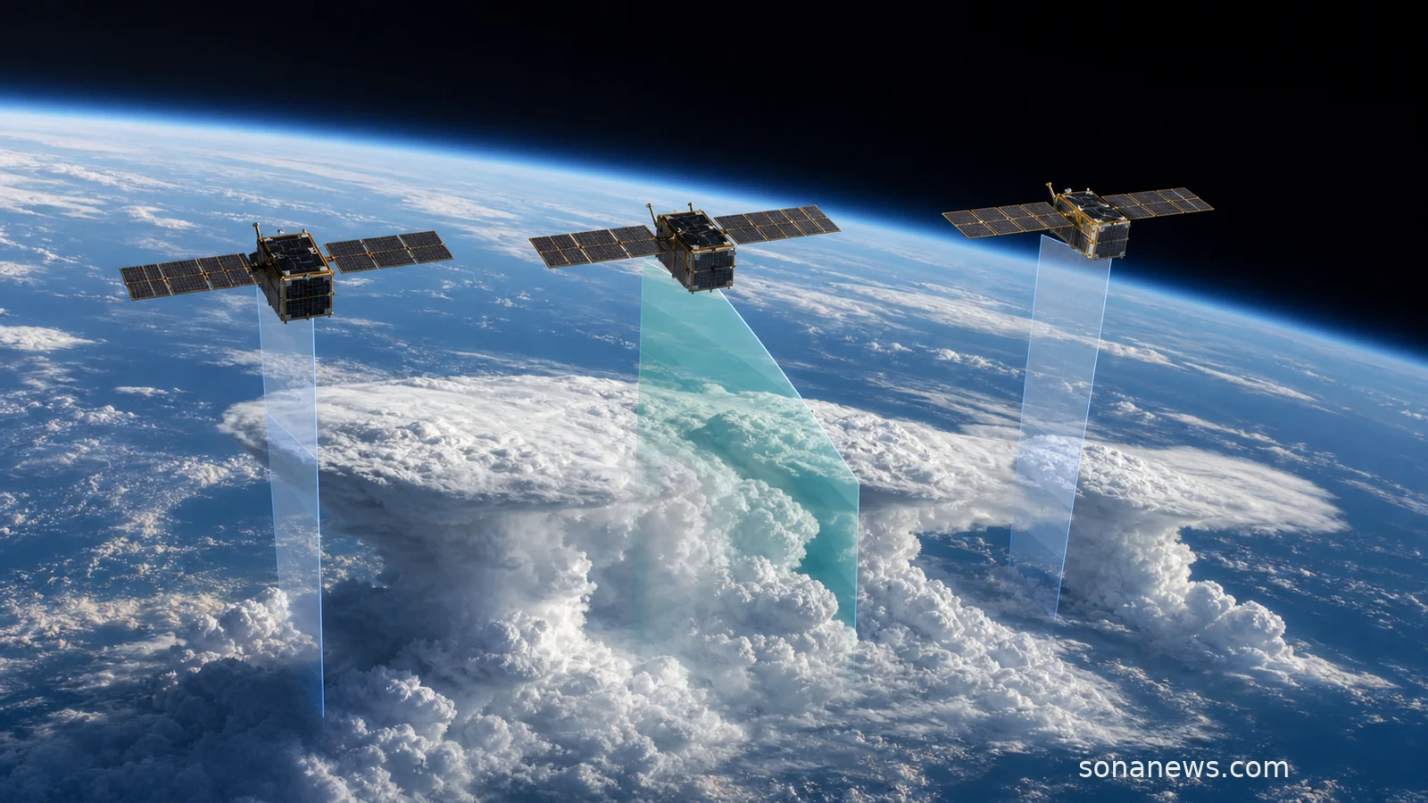
INCUS tries to answer that with choreography. The three SmallSats will fly in tight coordination, not as a loose collection of weather cameras. NASA says the first and second satellites will be separated by 30 seconds, with the second and third separated by 90 seconds. The mission overview describes the sequence as observations 30, 90 and 120 seconds apart. That is the point: the satellites are meant to watch the same storm structure more than once while it is still evolving.
Each spacecraft carries a RainCube-like Ka-band radar, while the middle satellite also carries a TEMPEST-D-like microwave radiometer. In plain English, the radars are there to look into storm structure, while the radiometer gives wider context for the surrounding cloud and precipitation scene. The technical detail matters because a single snapshot can hide motion. Three closely timed passes can show change.
That does not make INCUS a magic forecast button. A 2027 launch is still ahead, and a satellite mission has to survive launch, deployment, commissioning and the ordinary wear of space before its data can become routine science. Even then, the first payoff is likely to be better understanding and model evaluation, not an instant public alert on a phone. The safest reading is the least theatrical one: better observations can give researchers a firmer grip on a process that weather and climate models need to represent.
There is also a quieter reason to care about a mission like this. Many people meet space science through the spectacular end of the subject: eclipses, rocket plumes, black holes, astronauts. INCUS belongs to the less showy side, where orbit is useful because Earth is large, tropical oceans are hard to sample continuously from the ground, and storms change faster than tidy daily summaries suggest. The mission is a reminder that some of the most practical space work is not about leaving Earth behind. It is about looking back at the atmosphere with a better clock.
The timing theme is what keeps the story grounded. NASA’s 2025 launch-service award says the satellites will fly on a Firefly Alpha rocket from Wallops. The vehicle and contractor are operational details, not the core public promise. The core promise is that repeated views, seconds apart, may help scientists connect rising air and water to the severe weather that sometimes follows.
That is a modest claim, and it is better for being modest. INCUS will not tell a household what to do during a storm, and it should not be treated as a substitute for official weather warnings. If it works as planned, its value will be upstream: data for scientists, tests for models and a clearer view of storm growth before the forecast reaches anyone’s lock screen. For a space mission, that is not a small ambition. It is a practical one.
Editorial note. This article explains a space-based research mission and is not a weather forecast, emergency bulletin or storm-safety guide. For actual severe weather, follow official meteorological warnings, local emergency instructions and relevant public-safety authorities.
Sources
- Source: "NASA’s INCUS Mission on Road to Launch, Study Storms From Space", NASA Jet Propulsion Laboratory, Extracted 2026-06-28. Verified: June 5, 2026 update; two of three SmallSats assembled and tested; third testing no earlier than September; 2027 launch planning; tropical convective storms framing; more than half of world precipitation; mission purpose
- Source: "NASA’s INCUS Mission on Road to Launch, Study Storms From Space", NASA Small Satellite Missions blog, Extracted 2026-06-28. Verified: low Earth orbit formation; 30 second and 90 second satellite separation; convective mass flux definition; radar and radiometer roles; Wallops launch-site preparation; completed vibration, thermal vacuum and reflector-deployment testing for first two observatories
- Source: "INCUS", NASA Science, Extracted 2026-06-28. Verified: mission name, future mission status, Earth orbiter classification, no-earlier-than 2027 launch timing, three tightly coordinated SmallSats and objective to study storm formation
- Source: "INCUS Mission Overview", Colorado State University, Extracted 2026-06-28. Verified: mission goal, core science questions, convective mass flux focus, first tropics-wide investigation wording, three SmallSats, RainCube-like radars, TEMPEST-D-like radiometer and 30, 90 and 120 second time-differencing concept
- Source: "INCUS Mission Plan and Instruments", Colorado State University, Extracted 2026-06-28. Verified: three Ka-band radars, one scanning radiometer, two-year mission duration, 38 degree inclination, around 95 minute orbit, all-longitudes observational plan and instrument-resolution details
- Source: "NASA Awards Launch Service for Mission to Study Storm Formation", NASA, Extracted 2026-06-28. Verified: Firefly Alpha launch selection, Wallops Flight Facility launch site, mission selection and management context, Susan van den Heever as principal investigator and participating NASA centres
Help us improve
Was this article useful?
One anonymous tap helps Sona improve future reporting, headlines and source context.
Up next
The headline is a launch award. The useful story is that TSIS-2 and PolSIR will watch two awkward parts of the Earth system: the Sun’s incoming energy and tropical ice clouds that change through the day.
Continue readingMore in Space